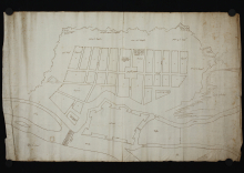
The drawing was made as a plan for the camp of a large imperial army recruited for the 1566 campaign of Holy Roman Emperor Maximilian II (1564–1576) at Győr, after the city was designated as a gathering place for Christian troops. The deployment of an army of about seventy thousand people required serious preparation: the precise definition of the camp site, which in this case, is the relatively flat area enclosed by the Danube and Rába rivers, and by protective ramparts. Each team had to be positioned so that the movement within the camp would be possible, and also taking into consideration other aspects like the rank of the team leaders, nationality, number of weapons, type of weapon, location of cannons, safe storage of gunpowder, and so on. Presumably a copy of the present drawing was received in advance by the troops arriving at the scene, in order to facilitate their camping. The copy of the plan preserved in Modena was probably placed in the family archives by the military engineers of Alfonso II d'Este (1559–1597) Duke of Ferrara, (brother-in-law of Emperor Maximilian II). The Duke arrived at the camp at Győr with his troops in August 1566.
The drawing itself is a simple sketch with few inscriptions and some geographical names: Giavarin, Danubie, Isola di Comar, Borgho. It shows the areas for artillery and ammunition (piaza per la monizion della artigliaria (1)), the piaza del imperator (2) in the middle of the camp site, so the place designated for the emperor's escort, the roads (strade) and the area between the ramparts and camp sites, piaza per la bataglia (3), meaning battlefield.
The original record held by: State Archives of Modena
Reference code: Archivio di Stato di Modena, Mappario Estense, Militare, n. 129
Date of creation: Győr, 1566


